|
Location information has
historically been an underused piece of data. An odd fact
considering that 80~90% of databases have at least some
form of location information, such as a store, office or customer's
address. To a large extent this underutilization is because traditional business applications were never
designed to leverage or understand the spatial relationships
that exist between various data sources. This has made it harder
for companies to see the big picture when it comes to
working with multi-dimensional and disparate data,
particularly as data often appears unrelated unless viewed
within a spatial context. For example, if your
data doesn't know "where" it is, you'll be unable to draw
connections between customers and stores, uncover trends and
patterns that are occurring in different areas or identify
new opportunities for market growth or operational
efficiencies.
Apart from the advantages above,
one of the other great benefits
of location powered intelligence is that it provides one of
the most intuitive visualization methods known today - the
map. For centuries people have been using maps to navigate
paths, determine courses of action, identify important points and draw
boundaries between territories and zones. Maps help people
understand where they are and where they are going, and in
the context of business, help companies stay organized and
focused. By displaying business data against the backdrop of
a map, managers and analysts will no longer be asking "what
are the
numbers" but "where are the numbers". Their
view of the business landscape will be more holistic which
will ultimately help them make better, faster and more
informed decisions.
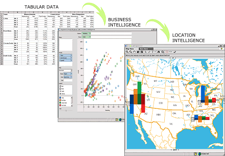
Illustration: This example shows how location
intelligence can take complex multi-dimensional data and
then display it in a intuitive manner that leads to greater
clarity and understanding, resulting in
better, faster and more informed decision making.
Click image to
zoom in and learn more about this visualization
 |