|
The Localligence
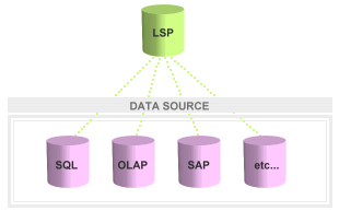
solution is built around a server that resides
locally at the customer's site, or remotely at the
Localligence data center. This server (Localligence
Spatial Platform) consists of several applications that work
together to spatially enable a customer's database.
To do this, corporate data needs to be processed by
the LSP and two values, latitude and longitude, need
to be added as values to each record.
Illustration: Spatially enabling an enterprise's
data.
Once corporate data has
been spatially enabled, applications are then built
or customized using Localligence APIs. These
applications interface to the Localligence Spatial
Platform (LSP), leveraging the location intelligent
functionality and visualization techniques provided
by the LSP.
|
|
|
|
|
Localligence provides a
number of extensible object orientated APIs in Java and C++
with additional software
components available as Active X or .NET controls.
Our web services can be interfaced by XML, HTTP or PHP. The Java API is platform independent and
therefore runs on any Java-enabled OS. The C++ API
runs on Microsoft Windows (32 bit) as well as
the Microsoft PocketPC platform.
|
 |
|