|
|
|
The insurance industry is built around location,
more specifically, proximity. For example, knowing exactly where something is in relation to something else, such
as how close a house is to a hazard. This approach is fundamental to how insurance companies manage risk as well as ensure a profitable portfolio.
|
|
|
|
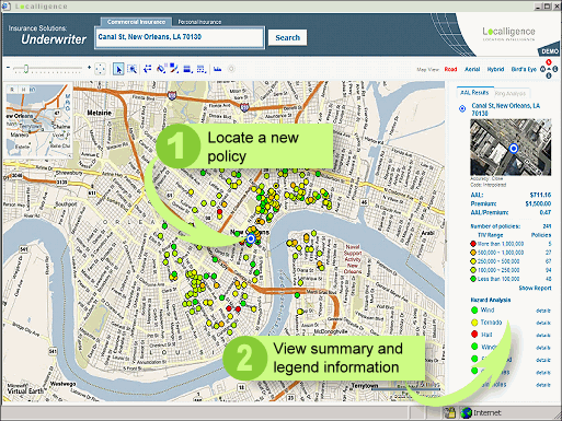
Insurance Underwriters are the people who decide
whether or not to accept policies for properties,
such as houses, cars
and offices.
Typically these underwriters have limited visibility
and understanding into how a new policy can
increase an insurance company’s risk exposure, adversely affect overall profitability.
For example, generally an Underwriter is unaware of nearby hazards, how
many policies already exist in the area or what the
potential loss might be for the new policy. In most
cases this analysis is done after the fact, often
three to six months later – which exposes insurance
companies to even greater risk, risk that ultimately
affects profitability. Using the Localligence
Insurance Underwriting solution, Underwriter's are
now able to better understand the
potential risk of a new policy: what’s the annual
average loss (AAL) expected for a similar policy in
the same area, how many policies already
exist in the area and what hazards are nearby.

| |
|
|
|
|
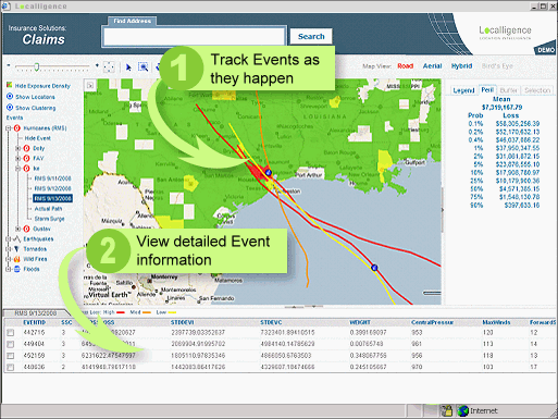
Responding to loss as a result of natural or
man-made events is one of the key obligations of an
insurance company. Insurance customers pay premiums to
protect their assets in such events, and the ability
to respond quickly is an important customer service.
It is also important for management to be kept
informed of the potential losses during an event.
Hurricanes, in particular, can cause hundreds of
millions of dollars in losses for an insurance
company, and understanding this impact in real time
is a critical part of executive management. With
Localligence Insurance Solutions, Claims agents are able to log
into the Localligence application and select an
event from tornados, hail storms and earthquakes, to
hurricanes and wildfires. By overlaying the event on
the map, agents can then display all the policies
that might be affected, as well as get a summary of
the potential loss by looking at the Total Insured
Value (TIV) of all the policies. In the case of
hurricanes, real time updates are provided three
days before expected landfall, allowing insurance
companies to track the projected path and to then
perform buffers of each path to look at the
potential loss should the hurricane continue. Post
event, agents are able to zoom into the map and
identify each policy that might have been effected,
adding them to a “Visit” list, along with driving
directions and maps for people in the field who are
tasked with providing support and assistance
|
|
|
Copyright
Localligence LLC |
|
|
|